Energy infrastructure has been relying on legacy mapping technology for 40 Years: It's time for an upgrade.


Energize Insight: For decades, geographic information systems (GIS) have been the backbone of countless industries – from transportation to urban planning to disaster response, construction, education, and more. Yet despite the central role these systems play in our infrastructure, the software landscape has remained largely unchanged since the 1980s. While legacy GIS platforms have seen incremental updates, many still rely on architecture and workflows rooted in the desktop-first era. These systems have struggled to keep pace with the explosion of real-time data and the cross-functional collaboration needs of today’s infrastructure teams. The industry is ripe for innovation, and next-generation geospatial software and analytics solutions have emerged to meet this market need.
The Secret Backbone of Our Infrastructure
Across industries, digital innovation has reformed how we build, move, and inhabit our world. But even the most advanced tools fall short if they can’t map their insights to the physical world. That's where geospatial data becomes a crucial bridge - transforming abstract digital potential into real-world impact by anchoring data to physical coordinates and turning ideas into tangible decisions. This vital connection is the hidden foundation of smarter cities, safer infrastructure, and more strategic development.
Nowhere is this more apparent than in the climate sector. Renewable energy developers leverage massive amounts of geospatial data to identify optimal project locations, facilitate construction workflows, and manage operational assets. Meanwhile, climate risk and resilience planners process complex geographic information to identify areas at high risk for wildfires and floods - efforts that save lives and minimize destruction from increasingly common natural disasters.

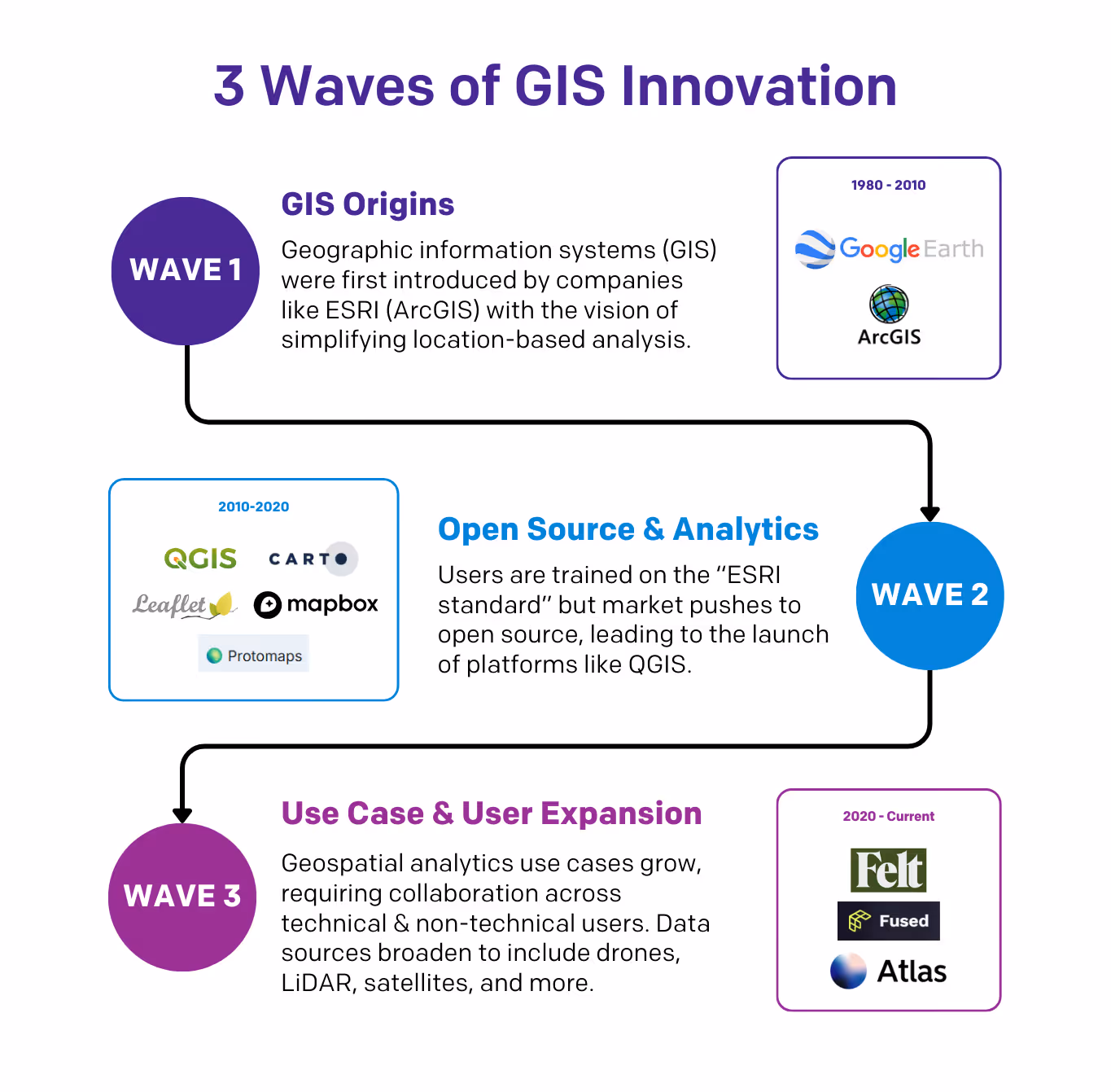
Three Waves of Geospatial Evolution
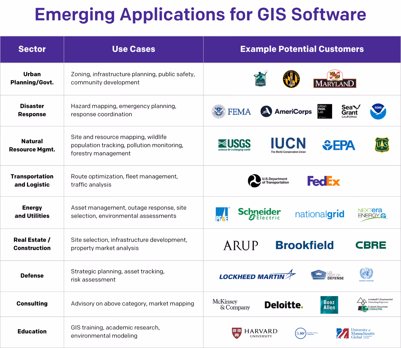
Despite this critical importance, the tools powering geospatial analysis have been very slow to evolve. Geospatial software first emerged in the 1980s to support location-based analysis, but for decades it remained largely limited to desktop systems used by technical specialists. Even as open-source alternatives and early cloud-based platforms gained traction in the 2010s, most tools still required expert users. The software evolved slowly, even as the range of applications expanded—supporting everything from urban planning to emergency response—but the user experience lagged behind innovations seen in other sectors.
Today, that’s changing. The volume and complexity of geospatial data have grown exponentially thanks to inputs from drones, satellites, IoT sensors, and more. At the same time, demand for spatial insights is expanding beyond GIS experts to professionals across industries. In response, a new generation of cloud-native platforms is emphasizing accessibility, collaboration, and real-time analytics—making geospatial tools usable by broader teams and more integral to business decision-making than ever before.
Why Now: Four Drivers of Geospatial Transformation
At Energize Capital, we research and fund industrial digitization solutions that enable scale and power the energy transition. We see a major use-case for advanced GIS technologies to reduce soft costs and improve the efficiency and effectiveness of essential infrastructure – an improvement that can drive both financial and impact returns for stakeholders in energy, transportation, and construction alike. Our analysis points to four key factors making this an opportune moment for next-generation GIS solutions:
- Growing business use cases - Enterprises across segments increasingly recognize the importance of geospatial data in decision-making. Approximately 25% of enterprises are leveraging more location data than they did three years ago, creating new demands for accessible tools that can handle this expanded usage.
- Expansion of data sources and applications - Geospatial data is surging, sourced from increasingly diversified technologies, including drones, AR/VR images, IoT sensors, and satellites. The number of Low Earth Orbit satellites has more than doubled since 2010, while commercial drone sales have grown from 634,000 in 2020 to over 2.3 million in 2024—all generating valuable data that requires processing and analysis.
- Labor shortages - As geospatial use cases broaden, demand for skilled analysts has outpaced supply. Total demand for roles requiring geographic information skills has increased by 98% from 2021 to 2023, yet many institutions have de-emphasized GIS programming. This gap creates an urgent need for more intuitive tools that can be used by a wider range of professionals.
- Technology advancements and AI - Advancements in cloud-based GIS systems, spatial data aggregation, and AI are expanding what's possible with geospatial analysis. Complex AI systems can now ingest massive amounts of data more easily, as well as surface key takeaways more easily – opening up new use cases for data types and applications across the ecosystem.
Overcoming Legacy Challenges
Despite widespread recognition of their importance, organizations still face significant hurdles in maximizing the value of geospatial data:
Challenge #1: Data Collection and Processing Complexity
Historically, collecting geospatial data was costly and difficult, often requiring the dispatch of helicopters and "boots on the ground." But with the widespread cost reductions and adoption of commercial drones, connected sensors, and satellite data, companies are now facing the opposite problem—managing mountains of data that traditional systems weren't designed to handle efficiently.
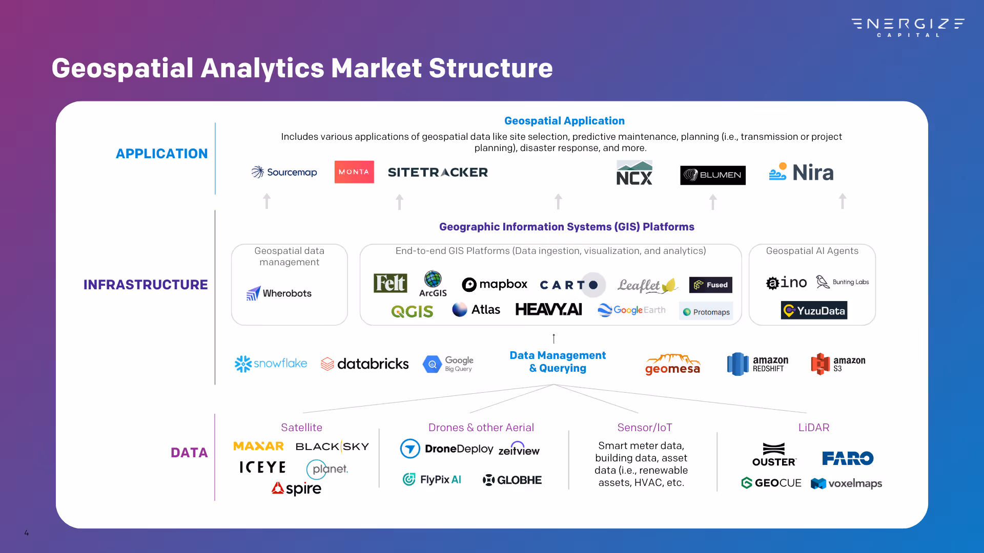
How can software help? New solutions are emerging to support both data collection and processing of complex geospatial information. Companies like DroneDeploy streamline the capture and analysis of aerial imagery, while specialized platforms like AiDASH, Overstory, and Urbint combine complex data structures with proprietary algorithms to extract useful insights – leading to faster O&M inspection for renewables, improved wildfire risk detection, and more. GIS tools can accelerate and expand data applications, enabling faster and smarter decision-making across critical industries.
Challenge #2: Technical Expertise Barriers
Companies collecting large volumes of geospatial data often struggle to extract value from it. Specialized formats like Shapefiles and KMLs require niche expertise to analyze and manage—expertise that’s increasingly scarce. This talent gap has become a major bottleneck for organizations trying to use location data in critical decision-making.
How can software help? New open-source and proprietary software solutions are being developed to more efficiently process and analyze complex spatial data. Tools like Apache Sedona (a unified large-scale analytics engine purpose-built for geospatial processing), Wherobots (a cloud-based Extract, Transform, Load [ETL] and analytics platform by the creators of Sedona), and Heavy AI (a powerful geospatial processing platform) create flows that streamline data analysis and reduce dependency on scarce technical talent. These platforms can empower non-specialist team members to participate in workflows previously gated by technical knowledge, enabling in-depth customer mapping to improve business decisions or user-friendly visualization of distributed energy assets.
Challenge #3: Collaboration Across Technical Boundaries
As powerful as ArcGIS (the dominant map-making tool in the market) and its open-source counterpart QGIS are, they were designed primarily for technical specialists rather than collaborative teams. Modern organizations need to bridge the gap between GIS experts and decision-makers across departments, especially as use cases expand beyond traditional engineering applications.
How can software help? Cloud-native tools that prioritize collaboration and accessibility are entering the market with a renewed vision of what map-making can look like in the modern enterprise. Platforms like Felt and Atlas AI provide interfaces that enable technical and non-technical users to work together on the same datasets – empowering more team members to use geographic data, like renewable development teams who leverage Felt to map ongoing and operational projects and collaborate on action items. Business intelligence tools with geospatial capabilities like Carto help translate complex spatial data into actionable insights for leadership teams, while developer-focused tools like Mapbox provide powerful APIs and SDKs that integrate location intelligence into custom applications.

What's Next: GIS for the Energy Transition
As the geospatial market continues to evolve, we expect to see deeper adoption across sectors, from energy and utilities to transportation, real estate, and beyond. Cloud-native platforms that emphasize collaboration will enable organizations to break down traditional silos between technical specialists and decision-makers.
For energy and climate applications in particular, next-generation GIS tools will accelerate renewable project development cycles, improve grid planning and optimization, enhance disaster response coordination, provide deeper insights for climate risk assessment, and more. By putting powerful spatial analysis in the hands of more stakeholders, these tools will not only help us better understand our world but help us build a better one.


Let’s Build What’s Next